Where is the Martinborough Fair held
The fair is held in the South Wairarapa town of Martinborough.
South Wairarapa Rotary Club secure a fair license from the District Council and the Club members mark out over 500 stalls on the roads, footpaths and in the central park.
Stalls marked out at either 6 x 3 metres or 3 x 3 metres and from October the 1st each year, applications are invited for use of these plots.
How are applications processed
All applicants are encouraged to apply as soon as possible as applications are processed in the order they are paid. (Not the order they are received!)
During the month of october, returning stallholders are given the opportunity to book the same site they had the previous year. From the 1st of November on, ALL paid applications are distributed around the remaining stall sites.
First, returning stallholders who have paid and indicated they want to move are assessed and if the target site has not been booked by last year's holder, they are moved.
Then, all paid applications are assessed by payment date order and remaining stall sites are filled.
Arriving at the Fair
There are four main access corridors to Martinborough.
- State highway 53 from either Featherston or Greytown
- Ponatahi Road fropm Masterton/Carterton
- Lake Ferry Road from Pirinoa/South
- There's also Longbush/Hinakura from the East
The Fair is set up around the central square so when you drive in, you can circumnavigate the centre by using Strasbourg, Venice, Sackvill or Ohio streets, and choose a spoke road that will take you closest to your stall site.
Finding your site
NOTE: No vehicles are allowed on the grass in the central park area.
Locate your site on the maps (see below) and park temporarily nearby. The sites are marked with 2 letters, indicating the sector, and 2 numbers. (See below).
If there are only 2 numbers, it is expected that you will know what road you are standing on. If you are in Oxford Street for instance, all the sites can be assumed to have an OX prefix to the 2 numbers you see. Make sure you are at the correct site
Walk around and find out where your site is and assess any access issues.
Where is the closest parking you can get to for your setup operations?
Once you have evaluated your logistical options, park your car as close as you can to the site. If you are in the central park, you might be able to get down one of the paved accessways that lead to the atrium, and carry your stall gear to the site from there. Please move out as soon as you can to let others in. Note; Bring a hand truck or trolley with you for the purpose.
Can you fit your proposed equipment on the site? If you think there will be issues, contact the Fair HQ (in the Fire Station) for resolution.
Setting up
Set up within your 6x3 boundary. If the marking out is innaccurate, please be patient and pragmatic. Our volunteers do their best but are not always perfect. We can and will sort it out for you. the kines are there to guide - and if they were washed away in the night we all need to work together to get everyone sited. Don't just plonk yourself down in everyone's way. Get some advice from the roviing site marshals (white coats)
Once the roads are closed there is to be no further traffic movement. If you find you have become trapped, get a site marshall to help you get out. Don't just edge out through the pedestrians!
Running your stall
Keep within the bounds set up by marking or by the area marshals. Don't expand your site during the day, you will be made to pull it in again and if the marshals report poor compliance, you will find it difficult to get a site the following year.
Communicate with the customers. There are over 500 stalls so there is information overload. You will need to communicate clearly and often. Display your goods cleary. Go out and take a look at you rsite fro a customer perspective. If you were looking atthe site for the first tim, whould you know what was on sale and how to get it/
Breaking down and leaving
No one leaves before the roads are opend. This is a safety issue.
Everyone is in a hurry to catch the next ferry or get ahead of the traffic. Please! be kind, be thoughtful and considerate. You are not the only one wanting to get packed up and get home or to your next appointment/gig/fair.
Overall layout of the Martinborough Fair.
The map below has links that will allow you to view the detailed stall layout maps of each of the sectors
Note that North is at the bottom left corner of the map
Our fair has between 450 and 520 stalls laid out around the town in sectors that have each been allocated 2-letter identifiers. (OX, CA, QE etc)
The stall sites are either 6 metres x 3 metres, or 3 metres by 3 metres where possible.
The maps are not cartographically correct - they are a near approximation of the layout and sizes cannot be accurately inferred from them.
- CA = Cambridge Street
- JE = Jellicoe Street
- KI = Kitchener Street
- KS - Kansas Street South
- MN = Memorial drive North
- MS = Memorial drive South
- ME = Memorial drive East
- MW = Memorial drive West
- MT = Mitre 10 carpark
- ON = Ohio Street North
- OX = Oxford Street
- QN = Quadrant North
- QS = Quadrant South
- QE = Quadrant East
- QW = Quadrant West.
- TE = Texas Street East
- TW = Texas Street West
Stalls are identified with a 2-letter identifier and the 2-digit number that relates to the stall's position within its sector. (e.g. OX21 = site 21 in Oxford Street). Each sector's sites are numbered from 00 to 99, so each sector will use the same range of numbers, but will have a different identifier (e.g. CA21 vs MN21)
There are around 100 sites in the central grassed area (The Quadrant), another 200 around Memorial Drive (ME, MS, MN and MW) and a further 20 - 100 or so down each street radiating from Memorial Drive.
In the quadrant ( QN, QS, QE, QW) sites may be drawn on the maps as 6x3, but if there is a tree or other obstruction on the site, it may be classified as 3x3.
In addition, some sites in the square might not be suitable for siting Gazebos.
To view a detailed stall layout map of a sector, tap or click on the blue links on this map. (Small mobile phones may need to view this map in landscape mode to access the tap-links)
Map symbols
 Change window - Stallholders can get change for large denomination notes.
 Information Kiosk - Fair and Stall information, Lost property, Public address, and information about Rotary
 Water - Tap water or drinking water.
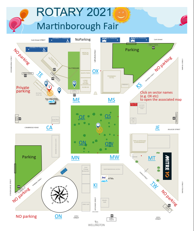
Image Gallery


https://martinboroughfair.org.nz/foodstuffs-other-1/item/457-fair-layout-and-maps#sigProIda73365861a